 SECHELT
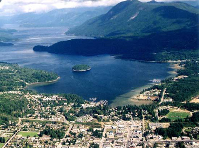
Sechelt's central location on the southern peninsula of the Sunshine
Coast makes it a natural hub for business, culture and tourism.
The thriving village is surrounded by beautiful mountain scenery
and a natural seaside beauty that lends a special charm to the attractions
and amenities of the Heart of the Sunshine Coast.
The Sechelt area climate is characterized by mild, moist winters
and warm dry summers. Temperatures on the Coast range from freezing
in winter to highs of 30C (90F) in summer. The annual rainfall is
approximately 100cm (40in.) The Sunshine Coast is sheltered from
the open Pacific, and the milder weather patterns result in very
light snowfalls in the region.
The Sunshine Coast is split into two portions on either side of
Jervis Inlet. Roughly speaking, the southern half between the ferry
slips at Langdale and Earls Cove occupies the Sechelt Peninsula,
while the northern half between the ferry slip at Saltery Bay and
Lund sits on the Malaspina Peninsula.
Population: 8,488
Location: Sechelt is located on Highway 101 on
the Sunshine Coast, which is accessible from the rest of the Lower
Mainland only by boat or airplane. Travellers aboard BC Ferries
leave Horseshoe Bay in West Vancouver for the 9.5-mile (15.5-km)
ride to Langdale on the Sechelt Peninsula (45 minutes). Highway
101 links Langdale with Sechelt, 9 miles (15 km) to the north.
Approaching from the north, BC Ferries also connects Comox on the
east side of central Vancouver Island with Powell River on the Malaspina
Peninsula. On the southern coast of the Malaspina Peninsula, the
ferry terminal at Saltery Bay connects with Earls Cove on the northern
Sechelt Peninsula and Highway 101.
Coach Lines operate daily to connect the Sunshine Coast with Vancouver,
and a bus service between Sechelt and the ferry terminal at Langdale
is provided by BC Transit and local bus services. Air services include
scheduled flights from Sechelt to Victoria, and a daily float plane
air service from Sechelt to Vancouver and Nanaimo.
- Don't miss the impressive House of Hewhiwus (House of Chiefs),
the Sechelt band government offices and home to the Sechelt Nation's
cultural centre, which houses a museum, an art centre, a gift
shop and the Raven's Cry theatre.
- Visit historic Rockwood Lodge, a Union Steamship resort built
as a boarding house in 1935, a time when all visitors to the Sunshine
Coast arrived by boat at a wharf in Trail Bay. Rockwood Lodge
now hosts Sechelt's internationally acclaimed Festival of the
Written Arts.
- Top Canadian authors gather at Rockwood Lodge in mid August
for the annual Festival of the Written Arts. Listen to your favourite
authors who enjoy talking with their readers, and share a glass
of wine with fellow travellers who appreciate story telling. Sechelt's
summer celebration of Canadian writers and writing is very popular,
so book early.
- Twelve Coast Salish totem poles look out over Trail Bay - they
recount the history of the Sechelt Indian Band, the first in Canada
to gain self-government in 1986.
- The Sunshine Coast Arts Centre, located within walking distance
of downtown, offers continuous showings for local artists and
continues to expand with exciting and innovative programs. Raven's
Cry Theatre seats 274 guests and is the perfect venue for concerts,
live theatre & musicals and weekly first-run movies.
- Learn about the life cycle of the salmon at the Sechelt Hatchery,
near Porpoise Bay Provincial Park.
- The Chapman Creek Fish Hatchery on Field Road has an education
centre detailing the life cycle of salmon, and offering scheduled
tours for schools and groups. Visitors can see the tiny fingerlings
ready for release into Chapman Creek.
- The community of Wilson Creek south of Sechelt is a large rural
and residential area, and the location of the regional airport
and the Wilson Creek Campground. This community was named after
James Wilson, a blacksmith employed by the Burns and Jackson's
Brothers Logging Camp in 1898.
- Steamboats such as the All Red Line's S.S. Selma provided the
transportation needed to establish a settlement within the community.
The Union Steamship Company purchased the property and cabins
in 1917 in today's Selma Park, and expanded on the resort theme.
Today Selma Park exists as a quiet residential neighbourhood that
stretches along Highway 101.
- Davis Bay, less than 3km south of Sechelt, is one of sandiest
and most accessible beaches on the Sunshine Coast. Just pull off
beside Hwy 101 at a likely looking spot and let the picnicking
begin. The sweeping views here across the Strait of Georgia to
Vancouver Island are unbroken by any offshore islands, and are
a rarity along the otherwise sheltered coastline. A pier juts
a long way out from the beach, a good indication of how shallow
the water is. In summer, when the tide rises over the beach exposed
to the warmth of the summer sun, the ocean warms up as it absorbs
all that solar energy and provides swimmers with a Mediterranean-like
setting. Purple-hued sand dollars add to the ambience; their shells
fade to a bleached white when their life cycle is complete. The
sandy beach may yield clams, but your best bet is casting from
the pier here for salmon.
- The community of West Sechelt is situated on a large plateau,
offering one of the few suitable locations for agriculture in
the municipality. In 1915, farms were established by pioneers
such as W. J. Wakefield and Abe Mason, today West Sechelt has
the second largest population within the District, and is the
location of substantial new residential developments.
- East Porpoise Bay includes a mixture of industrial and residential
areas, including the new subdivision of Porpoise Bay Estates.
One of the highlights of the neighbourhood is Porpoise Bay Provincial
Park, located on the west side of East Porpoise Bay road.
- West Porpoise Bay and Sunshine Heights features spectacular
views of Sechelt Inlet, and the relatively flat, serviced land.
Residents also have easy access to the Village of Sechelt, Kinnikinnick
Park, the Arena and the Sechelt Golf & Country Club.
- Initially developed for summer cottages, Sandy Hook grew substantially
after 1963 when a development company started to build permanent
homes and cottages in the area. The name, Sandy Hook, was named
after sand was placed on the waterfront area to make it more attractive.
The area still retains a cottage 'feeling', with many of the homes
overlooking Sechelt Inlet. Additional features of the area include
a children's park, and a boat launching facility.
- The residential community of Tuwanek is located on the east
side of Sechelt Inlet at the foot of Mount Richardson. The name
is derived from one of the original four "septs" (division
of the Sechelt Nation) located around Narrows Arm. Tuwanek is
the eastern gateway to the Tetrahedron Plateau and Provincial
Park. Attractions include the Tillicum Bay Marina and the Gray
Creek Fish Hatchery.
- The marshland around Sargeant Bay Provincial Park is an important
stopover for waterfowl such as harlequin ducks, Canada geese,
and trumpeter swans, as is the upland area for a host of migratory
songbirds. Local volunteers have undertaken an ambitious project
to restore wildlife habitat around the bay.
- Some of the oldest yellow cedar and western hemlock in western
Canada grow in the Caren Range, northwest of Sechelt. Home to
the marbled murrelet, a drab, starling-size seabird whose numbers
are in as precipitous a decline as the old-growth western hemlock
on which it depends, these mountains form the backbone of the
Sechelt Peninsula. Although most murrelets nest in cliffs and
rock walls, the marbled murrelet, having evolved beside the majestic,
ramrod-straight, temperate old-growth forest, lay their eggs on
the hemlocks' broad, moss-draped limbs.
- A bittersweet victory was gained in the Caren Range when the
last of the great Caren forest was recently protected as Caren
Provincial Park, but not before some of the oldest trees in Canada
- in excess of 2,000 years old - were cut by logging companies,
then left to waste! You'll have to drive a long way through open
hillsides before you reach the shade of the park, but the tranquillity
you'll experience there will be a grand reward.
- California and Steller's sea lions and harbour seals gather
during winter months at the mouth of Chapman Creek south of Sechelt.
Walk out onto Mission Point for the best views. The best approach
to the point is from the beach at Davis Bay.
- Snickett Park and Pebble Beach in Sechelt are good places to
head to once you've packed the picnic hamper full of goodies.
In case you've forgotten anything, you'll find it at one of the
shops on the Boulevard just off Hwy 101 in downtown Sechelt. If
you're in a hurry (a contradiction if there ever was one in this
laid-back environment), park yourself on Snickett's Pebble Beach
on Trail Bay adjacent to the Boulevard. If not, head 3 miles (5
km) north of Hwy 101 on E Porpoise Bay Road to the sandy shores
at Porpoise Bay Provincial Park on the Sechelt Inlet. As you'd
expect from a park this size, rows of picnic tables dot the beach,
which is sheltered by wistful willows.
- Sechelt's annual Sunshine Coast Country Music Festival (Sunfest)
in July is one of the major festivals on the Sunshine Coast.
- Boat launch locations around Sechelt include public ramps at
Chapman Creek, Sechelt, and Cooper's Green Regional Park in Halfmoon
Bay, and private ramps at Halfmoon Bay and Secret Cove.
|